Natural Disaster Risks in Houston
Exploring natural disaster risks in our region
In the greater Houston region, natural disasters have become more frequent, dangerous and costly. The risks are only projected to increase in the future, threatening Houstonians’ lives and livelihoods.
Why natural disaster risks matter to Houston
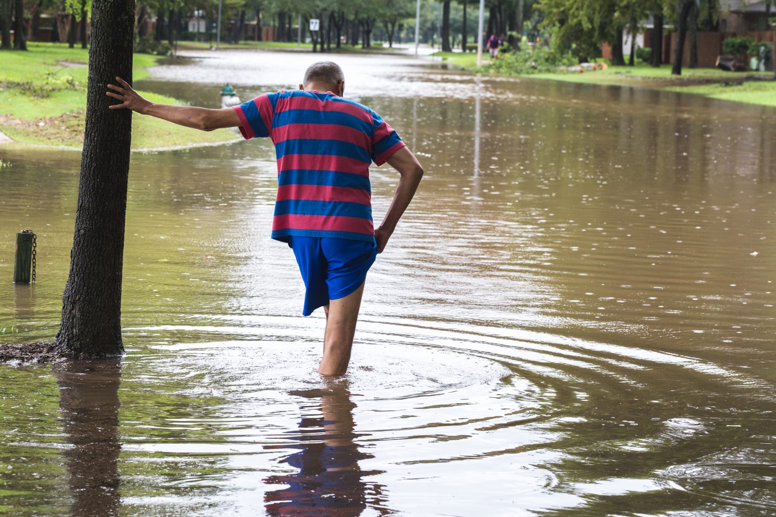
Those who live in Greater Houston are all too familiar with the risk of natural disasters in the form of flooding or hurricanes. Hundreds of thousands of properties in the region are currently at risk of flooding, and that figure is only projected to increase over time as storms become more intense and common. This increasing risk poses a threat to the safety of all residents. Without a stronger understanding of our current and future risk, our region’s residents and leaders cannot fully prepare for or mitigate the catastrophic consequences of frequent disasters.
The more we understand the scope of disasters and the effects of climate change in our region, the more we can do to minimize risks to our community.
The data
History of Disasters in the Houston area
The Federal Emergency Management Agency (FEMA) has declared a disaster in Fort Bend, Harris or Montgomery counties — the three most populous counties in Greater Houston — 26 times in the past 41 years, including the most recent severe winter storm in February 2021. Nearly a third of those (eight) have occurred since 2015.
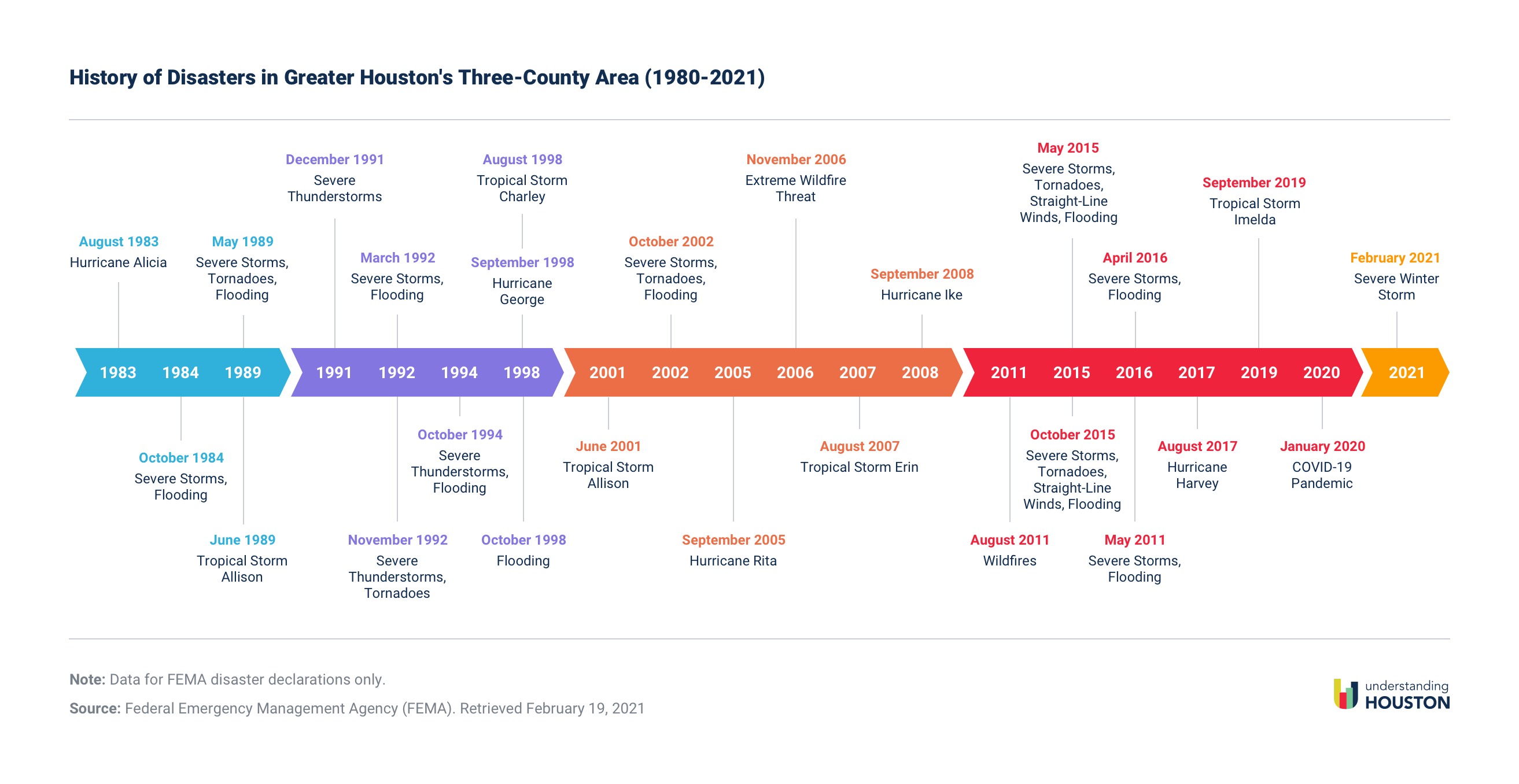
Since 1980, the Greater Houston region has experienced 12 major rain/thunderstorm and/or flood events, five hurricanes, five tropical storms, two wildfires, a pandemic caused by the new coronavirus, and, most recently a severe winter storm in February 2021 which caused week-long power and water outages, busted pipes, and boil water notices.
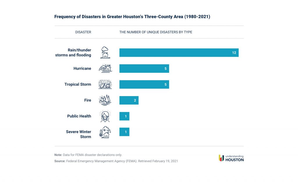
The fact that about half of these disasters were caused by unnamed storms would not surprise most residents of the Greater Houston area, where heavy rains and flooding are commonplace.
Flooding risk in the Houston area
FEMA creates flood maps to designate areas lying in different flood zones based on varying levels of risk. Properties identified as having at least a 1% chance of flooding in any given year (also known as the base flood or 100-year flood) are designated as a Special Flood Hazard Area (SFHA) — the highest risk. Areas that have a 0.2% annual chance of flooding (a 500-year flood) are considered more “moderate” risk.
However, these maps have limitations that don’t accurately predict where flooding occurs. An analysis of flood claims in southeast Harris County between 1999 and 2009 found that 75% of damages were outside the 100-year flood plain.1 The region experienced five major floods during that time, none of which met the criteria of a 100-year storm. Additionally, a 2012 study across the three decades before Hurricane Harvey found that 47% of flood damage claims made by Harris County residents were outside the 100-year flood zone.2 More than half (55%) of homes damaged in the Tax Day Flood in 2016 were outside the 500-year zone, as were one-third of homes damaged during the Memorial Day Flood in 2015, according to an analysis by the Houston Chronicle. Three out of four homes and apartments in Harris County that flooded during Hurricane Harvey were outside the 100-year flood zone, and half of homes damaged were outside all flood zone designations.
First Street Foundation has developed specialized floodplain maps using a model that expands on FEMA’s current maps. While the FEMA maps are based on risk from a single 1-in-100-year or 1-in-500-year event, First Street’s model considers additional factors, such as rainfall flood risk, current climate risk, and areas not mapped by FEMA.
First Street identified 244,842 properties that are at substantial risk of flooding (located within their 100-year flood area) in the three counties — that’s 56,680, or 30%, higher than current FEMA estimates of 188,162. First Street’s model found 60,411 properties are at risk of flooding in Fort Bend County compared to 13,227 identified by FEMA. This is primarily due to incorporating the chance of levee failure in their models.
Given Houston’s history of flooding well-beyond the designated “high risk” zone, current flood maps haven’t accurately predicted the extent of flooding in the region. The broadest measure of flood risk expands beyond the number of properties within the 100-year flood zone to include those located in floodways, “protected” by levees, and are in the 500-year flood zone. Using this definition, more than 322,000 residential properties (21.7% of all residential properties) in Greater Houston are located in a flood plain.
Harris County has the most residential properties located in a floodplain (234,404), the majority of which are in 500- and 100-year flood zones. In Fort Bend County, where 68,264 residential properties are at some risk of flooding, the majority of those properties are protected only by a levee. Most residential properties in Montgomery County that are at risk of flooding are located in the 500-year flood zone.
In Fort Bend, 29.5% of residential properties are located in all flood areas combined, compared to 21.8% in Harris County and 11.1% in Montgomery County.
Disproportionate flood risks
Research has shown that the communities most vulnerable to flooding are low-income and non-white.3 This is especially true in Houston where these groups have historically lived on low-lying land (a result of decades of discriminatory housing policies), receive fewer flood mitigation projects, and are characterized by decades of disinvestment, such as poor stormwater infrastructure.4 A recent study found that Black and Latino Harris County residents who lived outside the FEMA-designated 100-year flood zone were flooded at disproportionately high rates during Hurricane Harvey.5
This proves particularly challenging as low-income homeowners seek to rebuild or prepare for the next disaster. FEMA’s “50% rule” states that if the cost of improvements or the cost to repair a property exceeds half its [pre-disaster] market value (known as “substantial damage”) it must be brought up to current floodplain management standards. This regulation is particularly challenging for households living in homes appraised at lower values because the typical minimum cost of home repair after a flood is around $25,000. That means homes valued at less than $50,000, for example, are typically out of repair options and at greater risk of further damage when the next storm hits.
More than 32,000 residential properties valued at less than $50,000 are located in flood areas in the three-county region, with the majority being located in Harris County.
In Harris and Montgomery counties, homes that are valued below $50,000 are more likely to be found in a flood area. Across the three-county region, 23.3% of residential properties valued at $50,000 or less are located in flood areas, compared to 21.7% of all residential properties.
Future flood risk
We know that extreme rain poses a growing threat to the Houston area, which means the frequency and intensity of flooding will continue to increase. First Street Foundation projects more properties will flood in the future because of rising sea levels and changing hurricane patterns — consequences of climate change.
The number of properties in Harris County at risk of flooding is projected to increase to 204,513 in 2050 (up 21.7% from 2020). As many as 64,000 in Fort Bend and 17,600 in Montgomery counties are at “substantial” risk of flooding in 2050.
That means potentially one in seven (14.2%) of properties in the three-county region will be at risk of flooding by 2050. That is about one in five properties in Fort Bend, one in seven in Harris, and one in 15 in Montgomery counties — each higher than the rate for Texas overall.
References:
- Blessing, R., Sebastian, A., & Brody, S. (2017). Flood Risk Delineation in the United States: How Much Loss Are We Capturing? Natural Hazards Review, 18, 04017002. https://doi.org/10.1061/(ASCE)NH.1527-6996.0000242.
- Highfield, W.E., Norman, S.A. & Brody, S.D. (2013). Examining the 100‐Year Floodplain as a Metric of Risk, Loss, and Household Adjustment. Risk Analysis, 33: 186-191. https://doi.org/10.1111/j.1539-6924.2012.01840.x.
- National Academies of Sciences, Engineering, and Medicine. (2019). Framing the Challenge of Urban Flooding in the United States. https://doi.org/10.17226/25381.
- Chakraborty, J., Collins, T.W., & Grineski, S. E. (February 1, 2019). Exploring the Environmental Justice Implications of Hurricane Harvey Flooding in Greater Houston, Texas. American Journal of Public Health, 109, no. 2: pp. 244-250. https://doi.org/10.2105/AJPH.2018.304846.
- Smiley, K.T. (2020). Environmental Research Letters, 15 0940b3. https://doi.org/10.1088/1748-9326/aba0fe.